Which Province and District Is Ayder Plateau In?
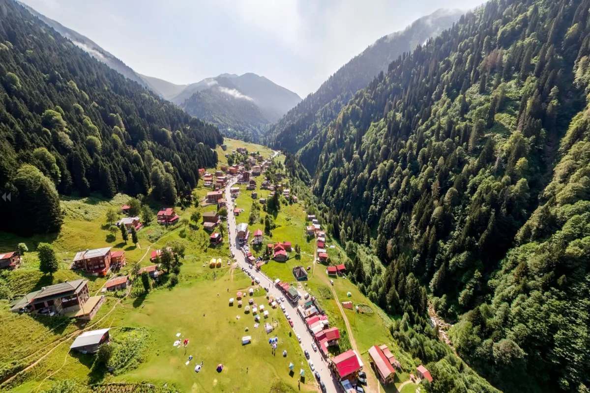
Ayder Plateau is located in the province of Rize in the northeastern part of Turkey. It lies within the district boundaries of Çamlıhemşin and is one of the most popular tourism destinations of the Eastern Black Sea Region.
With its lush green nature, traditional highland atmosphere and famous thermal springs, Ayder attracts thousands of local and international visitors every year.
Positioned at the foothills of the Kaçkar Mountains National Park, the plateau benefits from a rich natural and climatic structure.
Ayder Plateau’s Location on the Map of Turkey
On a map of Turkey, Ayder Plateau appears just south of the eastern Black Sea coastline. Its closeness to the coast provides notable advantages in terms of accessibility.
-
Region: Eastern Black Sea
-
Province: Rize
-
District: Çamlıhemşin
-
Nearby major cities: Artvin, Trabzon, Giresun
The overall area is one of the regions with the highest rainfall in Turkey, resulting in a dense forest cover throughout the year.
Closest Airport to Ayder Plateau
The most convenient option for reaching Ayder Plateau is Rize-Artvin Airport, which opened in 2022 and is Turkey’s second airport built on reclaimed land over the sea.
Airport – Ayder Distance
-
Distance: 46 km
-
Travel time: Approximately 1 hour
-
Transportation options: Rental car, taxi, private transfer
After leaving the airport, the route follows the coastal highway toward Rize, then continues inland through Ardeşen and Çamlıhemşin to reach Ayder.
Nearby Cities and Districts to Ayder
Understanding nearby locations helps visitors plan their trip more effectively.
Rize – Ayder
-
Distance: 85 km
-
Time: 1 hour 30 minutes
-
Route: Rize → Ardeşen → Çamlıhemşin → Ayder
Ardeşen – Ayder
-
Distance: 55 km
-
Time: 55 minutes
Çamlıhemşin – Ayder
-
Distance: 18 km
-
Time: 20–25 minutes
The road between Çamlıhemşin and Ayder is fully asphalted and mostly renewed, providing a comfortable drive.
How Ayder Plateau Appears on the Map
Although Ayder is relatively close to the Black Sea coast, it sits inland in a mountainous region.
On a map, you can clearly see how the road follows Fırtına Valley before climbing toward the plateau.
Approximate Geographic Coordinates
-
Latitude: 40.954° N
-
Longitude: 41.126° E
Entering these coordinates into navigation apps will provide the exact location of Ayder Plateau.
Natural Location and Geographic Features of Ayder
Ayder’s geographical position makes it valuable both ecologically and touristically.
The plateau forms one of the entry points into the Kaçkar Mountains National Park, surrounded by forests, rivers, waterfalls and mountain ridges.
Connection with Kaçkar Mountains
Ayder is situated on the northern slopes of the Kaçkar Mountains.
Thanks to this location, the region offers easy access to:
-
High-altitude trekking routes
-
Mountain trails
-
Camping and hiking areas
Altitude of Ayder
-
Approximately 1,350 meters above sea level
This elevation ensures cool and fresh air throughout both summer and winter seasons.
Best Routes to Reach Ayder Plateau
The main routes used to reach Ayder are:
1. Rize-Artvin Airport → Ayder
-
Distance: 46 km
-
Time: 1 hour
-
Route: Coastal road + Fırtına Valley road
This is the fastest and most efficient option in 2025.
2. Rize → Ardeşen → Çamlıhemşin → Ayder
This widely preferred coastal route provides easy access.
After Ardeşen, the road follows Fırtına Valley with scenic views.
3. Trabzon → Rize → Ayder
For visitors arriving through Trabzon Airport, the route is:
Trabzon Airport → Rize → Ardeşen → Çamlıhemşin → Ayder
Total distance is about 150–160 km.
Road Quality and Current Conditions (2025)
Thanks to recent improvements, the Ayder road is now modern and visitor-friendly.
-
Fully asphalted
-
Numerous widened dual-lane sections
-
Ongoing tunnel and road renewal works
-
Safe to travel in both summer and winter
-
Rest points and scenic stops available along the way
Ayder is no longer considered a difficult mountain route; it offers easy access for all types of travelers.
Frequently Asked Questions (FAQ)
1. Where is Ayder Plateau located?
In Rize province, within the Çamlıhemşin district.
2. Which airport is closest to Ayder?
Rize-Artvin Airport.
3. How far is Ayder from the airport?
46 kilometers.
4. Is it difficult to reach Ayder?
No. Roads have been improved significantly.
5. What is the main access route to Ayder?
Rize → Ardeşen → Çamlıhemşin → Ayder.
6. What is Ayder’s altitude?
Approximately 1,350 meters.
7. How to find Ayder on the map?
Use coordinates 40.954° N / 41.126° E.
8. Can you visit Ayder in winter?
Yes, though fog and occasional ice should be considered.